The core water crossing motorcycle technique is timing: glacial streams in the Himalaya run lowest around 6 am and peak in the afternoon, so cross nallahs early. Walk any crossing you cannot see the bottom of, ride it standing in first or second gear on a steady throttle with your eyes on the exit, and turn back if the water is fast and above mid-shin.
- ~6 am low, ~2 pm peak: the daily cycle of a glacier-fed stream at Chhota Shigri; cross early.
- July carries 43% of the summer meltwater, the worst month for big crossings.
- 0.3 m²/s depth × velocity already floats a small car; a bike is far lighter.
- 0.08: tyre friction on ice, about a tenth of wet tarmac, so braking distance is about ten times longer.
- Standing, first gear, steady throttle, eyes on the exit: the crossing technique in one line.
On slush and black ice, the rules flip: tyre grip on ice is roughly a tenth of what you get on wet tarmac, so stay upright, avoid any input that loads the tyres suddenly, and wait for the sun if you can.
The broken high-altitude roads of Lahaul, Ladakh and North Sikkim throw three surfaces at riders that the plains never do:
- fast meltwater across the road, the nallah;
- slush that hides rocks;
- thin ice on shaded bends.
This post is for riders who have done a few hill trips and want the mechanics behind the usual advice, with numbers from glacier hydrology, tyre-friction tests and flood-stability research.
Why do glacial nallahs peak in the afternoon?
Glacial nallahs peak in the afternoon because they carry the day's meltwater, and melt follows the sun and air temperature with a lag of a few hours. At Chhota Shigri glacier in Lahaul, the meltwater stream peaked at about 2 pm on sunny days, shifted toward 5 pm on cloudy days, and fell to its lowest at about 6 am.
The team measured discharge by the area-velocity method about 1.5 km below the snout of Chhota Shigri, a benchmark glacier in Lahaul, for 10 to 15 days each September from 2003 to 2005. In September 2003, flow ranged from 0.47 to 0.83 m³/s. Within each day, discharge peaked at about 2 pm on sunny days and closer to 5 pm on cloudy days, with lows near 6 am. Years with little snowfall exposed more ice to the sun and produced higher discharge. The limit: short September campaigns on one small stream; summer peaks are larger and bigger rivers lag more.
Read the abstract (free)Seventeen years of field data show the glacier losing a mean 0.46 m water equivalent a year (7.87 m cumulative) and slowing by 25 to 42% in its lower ablation zone since 2003. Summer discharge starts rising in May and peaks in July, which carries 43% of the summer flow, against 38% in August and 19% in September. In July and August, discharge reached about 8 to 13 m³/s with a strong daily cycle that followed air temperature with a lag of roughly 2 to 4 hours. The limit: one glacier; streams fed by bigger catchments, or by rain, behave differently.
Read the paper (free)Put the two together and you get a riding rule. July carries the most meltwater of the year, and within each day the stream rises from a dawn low to a peak 2 to 4 hours after the warmest part of the day.
A nallah you splash through at 8 am can be a different river at 3 pm. That is why riders on the Manali to Leh road aim to clear the stretch around Baralacha La early; seasonal guides report water crossings there through mid-June, with occasional glacial-melt crossings later in the season.
At the end of June 2026, on a dry Monday, the Jhalma Nallah in Lahaul-Spiti rose without warning in the afternoon. Officials were clear that there had been no rainfall in the area: the surge was glacier meltwater. It washed away a section of the road that links the valley, and more than 50 tourist vehicles were stranded on either side.
Lahaul-Spiti's Superintendent of Police, Shivani Mehla, said restoration had begun and would take a few hours, and the Border Roads Organisation and the district administration worked on emergency repairs before the stranded tourists could be moved. No one was hurt. The timing is the lesson: a clear sky and a hot afternoon are exactly the conditions that turn a morning trickle into a road-cutting flood.
Republic World: Chaos in Lahaul-Spiti, glacier melt washes away road (30 June 2026)How do you read a water crossing before riding it?
Read a crossing on foot: stop, kill the engine, and walk the line you plan to ride with a stick, checking depth, speed and the bottom. If you cannot stand comfortably in the fastest part, the bike will not stay upright there either.
Flood research gives a useful yardstick. The University of New South Wales Water Research Laboratory towed full-size cars through test flows and set stability limits from the product of depth and velocity.
The numbers are for cars, but they show how fast stability disappears as water speeds up. The force of moving water grows with the square of its speed, so a stream that flows twice as fast pushes about four times as hard on your wheels and boots.
Commissioned by the New South Wales State Emergency Service, the study combined full-scale traction tests on real vehicles with scale-model flume tests to find when cars slide, float or topple. For small passenger cars (under 4.3 m and 1,250 kg), it proposed a limiting still-water depth of 0.3 m, a limiting depth of just 0.15 m in flow at 3 m/s, and an overall stability rule of depth × velocity no more than 0.3 m²/s. Large 4WDs got 0.5 m, 0.3 m and 0.6 m²/s. Traction fell rapidly once water rose above floor-pan level. The limit: no motorcycles were tested, and a 150 to 200 kg bike has far less mass and a narrower footprint than a 1,250 kg car, so treat these as upper bounds, not targets.
Read the report (free)Is this crossing a ride, a push or a wait?
| What you see | What it usually means | Decision |
|---|---|---|
| Clear water, visible bottom, ankle deep, slow | Low risk; main hazard is slippery rocks | Ride it standing, first gear |
| Milky grey water, bottom invisible | Glacial silt; hidden boulders and holes | Walk it first, every time |
| Standing waves or a roar you can hear | Fast flow, boulders rolling on the bed | Wait for morning or find another line |
| Water above mid-shin in the fastest part | Depth × velocity climbing fast | Push with help, or wait |
| Rising level while you watch | Afternoon melt pulse or rain upstream | Do not start; it will be worse midway |
What is the right body position and throttle through water?
Ride standing, in first or second gear, at a steady walking-to-jogging pace with a constant light throttle, and look at the exit, not the water. Steady throttle keeps exhaust pressure up and the rear tyre driving; a steady pace avoids a bow wave flooding the air intake.
- Prepare. Check your bike's air-intake height in the manual; never let water get near it. Loosen tank-bag straps you might need to undo, and switch off any electrical accessories you can.
- Pick the line. Usually slightly upstream of where you want to exit, so the current carries you onto it. Avoid the outside of bends in the stream, where it runs deepest and fastest.
- Stand. Knees gripping the tank, weight on the pegs, arms loose. A standing rider lets the bike move under him over rocks.
- Gear and throttle. First gear on rocky beds, second on smooth gravel. Hold a steady throttle; do not chop it mid-stream.
- Eyes up. Fix on the exit. Looking down at the water pulls you off line.
- If you stall. Do not restart if water may be in the intake. Push out, then drain and check before cranking.
- After. Drag the brakes gently for a few hundred metres to dry the pads, and check the chain, which glacial grit wears fast.

How slippery are slush, snow and black ice?
Very: tyre tests in Sweden measured a peak friction coefficient of about 0.08 to 0.10 for a winter tyre on ice and about 0.40 on snow, against about 1.0 on wet asphalt.
Black ice therefore gives you roughly a tenth of the grip you are used to, and summer-pattern tyres (what nearly every Indian touring bike runs) do worse.
The report fits a standard tyre model to braking and cornering measurements made by the Swedish road research institute VTI on snow and ice at Arjeplog, using a winter tyre, a summer tyre and a studded tyre at 2 to 6 kN load. Peak longitudinal friction for the winter tyre was 0.40 to 0.41 on snow and 0.078 to 0.10 on ice, compared with 0.98 to 1.05 on wet asphalt. The summer tyre managed 0.26 on snow and 0.077 on ice; the studded tyre 0.51 on snow and 0.16 on ice. The limit: car tyres on a test truck, not motorcycle tyres, and measured on prepared surfaces. Real black ice over gravel can be worse.
Read the report (free)See the data as a table
| Peak longitudinal friction (4 kN load) | |
|---|---|
| Winter tyre, wet asphalt | 1.02 |
| Studded tyre, snow | 0.51 |
| Winter tyre, snow | 0.4 |
| Summer tyre, snow | 0.26 |
| Studded tyre, ice | 0.16 |
| Winter tyre, ice | 0.078 |
| Summer tyre, ice | 0.077 |
Source: Svendenius, Lund University TFRT-7617 (VTI measurements, Arjeplog 2006) · Car tyres in controlled tests. Most Indian touring motorcycles run road or dual-sport tyres closer to the summer-tyre rows.
Friction translates directly into stopping distance. Braking distance scales with the square of speed divided by the friction coefficient, so dividing friction by ten multiplies braking distance by ten:
Use this to check what you just read: the calculator below runs the same formula with your own numbers.
Stopping distance on a slippery surface
How do you ride slush and black ice near Zoji La or Baba Mandir?
Ride ice by doing almost nothing: upright bike, low steady speed, a high gear for gentle drive, no front brake, and both feet ready to dab.
Black ice forms where afternoon meltwater runs across the road and refreezes after sunset, so it hides on shaded bends, under snow walls and on bridges, and is worst from dusk until mid-morning.
Water and ice run on opposite clocks. Ice is worst at dawn, the nallah is worst at 2 pm, and the safe window sits between them.
- Timing: cross known icy stretches late morning, after the sun has worked on them, and before the afternoon melt floods the next nallah. Read off the timing data above, that window is roughly 10 am to 1 pm.
- Line: ride the tyre tracks of trucks, where gravel or dirt often shows through; avoid the glassy dark patches, which are the ice.
- Inputs: no sudden throttle, braking or steering. Use the rear brake lightly and engine braking in a higher gear than usual.
- Slush: slush hides rocks and ruts. Stand, keep a steady drive in second gear, and do not follow a car too closely, because its tyres throw slush and stones.
- If it is solid ice across the road: stop, walk the bike with the engine running in first, feet down, or wait. A short walk beats a fall at altitude.
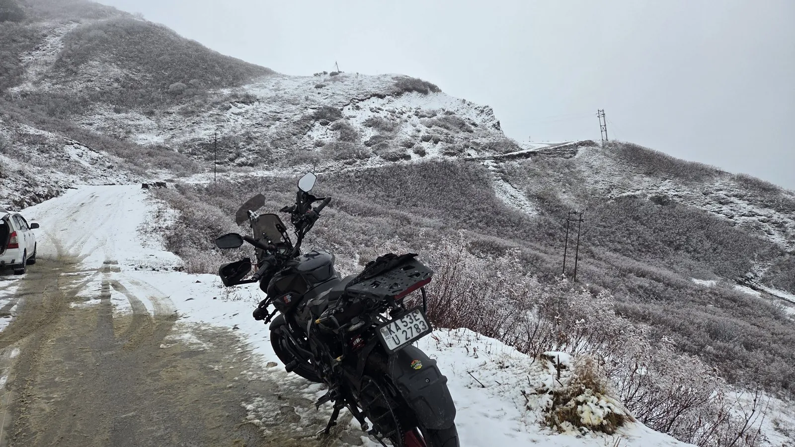
I have seen what thin cold does at altitude myself: near Baba Mandir in East Sikkim, at about 4,120 m in November 2025, ice formed on my visor. When the visor freezes, assume the road can too. Wind chill adds to the problem for the rider; my wind chill calculator shows how fast it bites at riding speed.
How should you plan a high-pass day around water and ice?
Plan the day backwards from the two hazards: ice until mid-morning, rising water from early afternoon. That leaves late morning for passes with ice and early morning for big nallahs, and on routes that have both, it means an early start and a stop before mid-afternoon.
| Time | Ice risk | Nallah level | Best use |
|---|---|---|---|
| 5:30 to 9:00 | Highest on shaded bends | Lowest | Cross the big nallahs; ride sunny slopes |
| 9:00 to 13:00 | Falling as the sun works | Rising | Cross the iciest pass sections |
| 13:00 to 17:00 | Low | Peak (about 2 pm sunny, nearer 5 pm cloudy) | Ride roads without crossings, or stop |
| After 17:00 | Rising again as melt refreezes | Falling slowly | Be at the night stop |
Weather moves those windows: a western disturbance brings fresh snow and cold, and the days after it bring ice. My guide to reading mountain weather and pass closures explains how to time that. For the route itself, use the Leh-Ladakh bike trip guide, and for tyres and bike set-up, the Yantra section covers the hardware.

What's new
- BRO reopens the Manali-Leh highway after 42 days of snow clearance; 26 avalanche-prone points on the Manali-Sarchu stretch The Tribune, May 2026
- Manali-Leh 2026 status: water crossings near Baralacha La through mid-June, light snow on the passes on 13 October Discover with Dheeraj, Oct 2026
- MeT Srinagar flags Zoji La as potentially unsafe during a mid-October western disturbance NewKerala (IANS), Oct 2026
Questions people ask
What time of day is best for water crossings in Ladakh?
Early morning. Glacier-fed streams fall to their lowest around 6 am and peak around 2 pm on sunny days, later on cloudy ones. Plan to reach big crossings before about 10 am.
How deep can a motorcycle go through water?
It depends on the air-intake height in your manual, but speed of flow matters more than depth. Car tests set a stability limit of depth times velocity of 0.3 m²/s; a bike is far lighter, so fast water at mid-shin is already a push-or-wait situation.
Should I use the front brake on black ice?
Avoid it. With friction near 0.08, a front-wheel lock is almost instant and usually ends in a fall. Use engine braking and a light rear brake, keep the bike upright and go slowly.
Is a road with snow on both sides safe to ride?
Usually, if the centre is wet tarmac. The danger is where meltwater from the snow walls crosses the road and refreezes on shaded bends after sunset, so ride those stretches late in the morning.
Sources
- Ramanathan AL, Sharma P, Jose PG: Discharge variations in Chhota Darra, Geophysical Research Abstracts (2007)
- Mandal A et al.: Chhota Shigri Glacier mass balance, meteorology, discharge and velocity 2002-2019, Journal of Glaciology (2020)
- Smith GP et al.: Vehicle stability testing for flood flows, UNSW Water Research Laboratory (2017)
- Svendenius J: Validation of the brush model towards VTI measurement data, Lund University (2007)
- The Tribune: BRO reopens Manali-Leh National Highway after 42-day clear-up (2026)
- Discover with Dheeraj: Manali Leh Highway status 2026 (2026)
- NewKerala: J&K forecast, snowfall in higher reaches (2026)
- xBhp forum: Need suggestions for a couple riding to Leh
- Republic World: Tragedy in Manali, chaos in Lahaul-Spiti, glacier melt washes away road (June 2026; Jhalma Nallah story)

Sapta (Saptarshi Sarkar) is a mechanical engineer turned marketer in Bengaluru and a solo touring rider. He writes the seven Saptaverse blogs. Work with him or read more of RoadHook Rides.